- October 23rd, 2012: JERICO TNA first glider mission started in the Balearic Sea.
- October 30rd, 2012: Mission temporary suspended due to battery problems; glider safely recovered 45 miles East of Menorca. The mission will re-start as soon as possible.
- January 31st, 2013: Mission re-started. SOCIB’s Seaglider sdeep03 is now heading to Oristano (Sardinia, Italy).
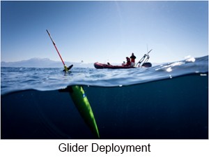 The first experiment under JERICO (http://www.jerico-fp7.eu/) TNA started on Tuesday October 23rd, 2012, with a deep glider mission from Minorca to Sardinia in the Western Mediterranean Sea. The mission is planned to end on December 10th, 2012.
The glider is part of the fleet operated by the Balearic Islands Coastal Observing and Forecasting System (SOCIB) and CSIC-IMEDEA (Spain). The glider will follow a route from the East of Minorca to Sardinia along the latitude 39º 49.457’ N and will return to Menorca and Mallorca./p>
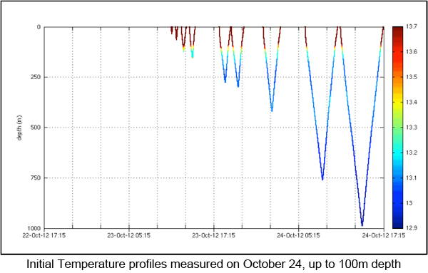
During approximately 49 days, the glider will cover a distance of about 380 Km in both directions, acquiring profiles of oceanographic data from the surface to about 1000 m. The glider is equipped with CTD (conductivity, temperature and pressure), oxygen, fluorescence and turbidity sensors.
Data measured will be transmitted through Iridium to verify sensors, sampling and navigation behaviour of the glider. Real time data transmission will be done at least every day (approximately 1 dive transmitted every 4 dives performed) to minimize communication costs and surface time (increasing platform safety). All data will be downloaded by cable once mission ends (delay mode).
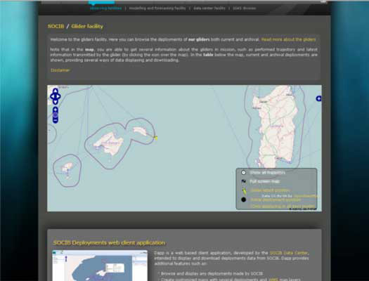
The glider track can be followed and is continuously updated using SOCIB Data Centre glider tools (http://www.socib.es/?seccion=observingFacilities&facility=glider and http://apps.socib.es/dapp/).
In accordance with the European glider workshop (JERICO/GROOM/EGO) hosted in Mallorca 22-23 May 2012, the real-time tracking data from gliders is available in a standard format, following international conventions (NetCDF) at the SOCIB Thredds discovery catalog (http://thredds.socib.es/thredds/catalog.html). Also the real time mission data is automatically uploaded to the EGO network (Everyone’s Gliding Observatory) for international data share and public access. The scientific data transmitted can be visualized at the EGO web page http://www.ego-network.org/dokuwiki/doku.php?gId=2045.
![]()
The mission is part of a research proposed by CNR IAMC in Oristano (P.I. Mr Alberto Ribotti) to the First TNA call of JERICO.
The central part of the Algero-Provencal sub-basin, where the glider mission is going on, is a buffer area between the northern Provencal sub-basin and the southern Algerian one, and is mainly characterized by the presence and action of the Balearic Front (interactions between more recent MAW and MW).
The purpose of the research is contributing to understand exchanges through the two sub-basins and the complex interactions through eddies. The area of work covers a transect between Balearic Islands and Oristano (Sardinia) that the Group in Oristano, in collaboration with the Institute of Marine Sciences of CNR in La Spezia, is annually repeating with CTD and current-meter casts for the last ten years during oceanographic cruises to study the inter-annual variability of physical and biochemical properties of water masses and understand the circulation, the exchanges through the sub-basins and the transport of salt and heat in the western Mediterranean.
In particular, the proposed research wants to identify the physical properties of the surface and intermediate water masses between Baleares and Sardinia with the aim of:
i) study the variability of the physical properties of surface and intermediate water masses between the Algerian and the Provencal sub-basins;
ii) evaluate the transport of water, salt and heat through the area and verify if the interannual variability of the surface and intermediate water masses is due to climatic changes;
iii) validate the operational hydrodynamic numerical model of the western Mediterranean (http://www.seaforecast.cnr.it/en/fl/wmed.php) through the use of in-situ and satellite data.
by Simó Cusí(1), Alberto Ribotti(2), Antonio Olita(2), Miguel Martínez Ledesma(3), Simón Ruiz(3), Joaquin Tintore(1,3), Stefania Sparnocchia(4)
(1)SOCIB; (2)IAMC CNR; (3)IMEDEA CSIC – UIB; (4)ISMAR CNR;