The JERICO Coastal Ocean Resource Environment (CORE) was a prototype e-infrastructure, initially labelled e-JERICO or JERICO CORE, developed under the JERICO-S3 EU-funded project, since February 2020. The Coastal Ocean Resource Infrastructure System (CORIS) was later born from the experience gained during the development of the JERICO-CORE. CORIS was officially endorsed as a UN Ocean Decade Action hosted by the CoastPredict Programme as a core project in September 2022. It is led by the Balearic Islands Coastal Observing and Forecasting System (SOCIB) and will be a key infrastructure to support the coastal ocean activities worldwide carried out by CoastPredict. JERICO-RI is consequently playing a strong role in the advancements of Coastal Ocean Research Activities with an impact worldwide.
CoastPredict is a programme endorsed by the UN Decade of Ocean Science and 1 of the 3 Programmes co-designed with GOOS. Through its 6 key focus areas, the programme aims to revolutionise global coastal ocean observing and forecasting. CORIS will support all Focus Areas in the CoastPredict Programme, but is most connected with the 5th Focus Area (FA5): Coastal information integrated into the open and free exchange international infrastructure.
Summary of CORIS
The Coastal Ocean Resource Infrastructure System (CORIS) will provide sustainable delivery of high-quality environmental data and information, products to research, industry, and government for purposes such as ecosystem health, hazard response and resource management.
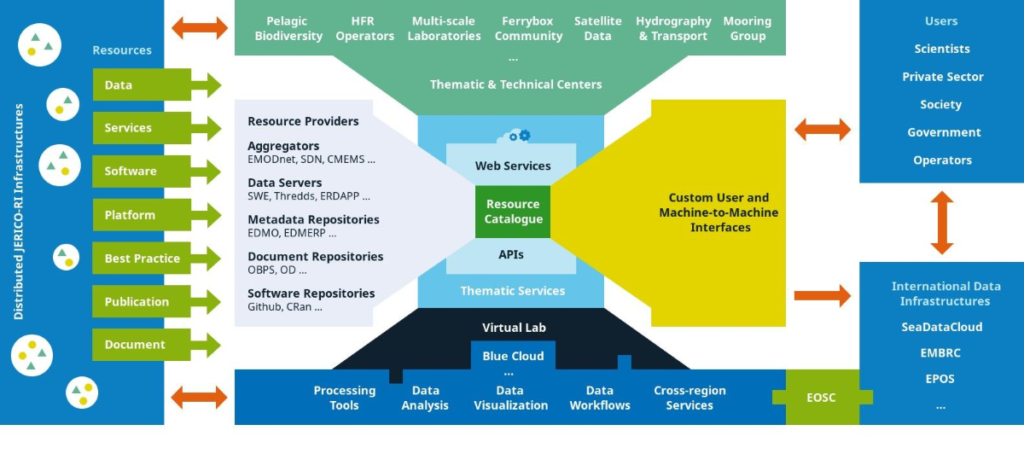
CORIS builds upon the JERICO projects and offers a range of services, including fully open access to data, tools for managing and using data, best practices for observation, data management and user applications, as well as access to relevant documentation.
There is also a virtual workspace for analyses and translating data into information. However, CORIS does not store data but collaborates with global and regional repositories such as EMODnet, NCEI, SAEON and AODN. This ‘one-stop shop’ will support countries with mature ocean capabilities and developing regions that have limited infrastructure. It will support all Focus Areas in the CoastPredict Programme.
 Objectives of the project connected to the Ocean Decade Outcomes
CORIS is an infrastructure to facilitate access to and use of ocean observatories, real-time and delayed mode data, information, tools, best practices and a virtual environment for supporting integrated analysis and coastal ocean prediction.
The high-level objective is to improve the foundation for global interoperability and facilitate access to the essential data and information necessary for the next generation of coastal forecasts and monitoring. CORIS will provide support for the assessment of the information of access to these resources such as FAIRness compliance and the impact of the coastal community activities. It will provide a workspace to collaborate in the development of custom-made tools for data analysis and processing.
This directly supports one of the three major objectives of CoastPredict, that there is a ‘FAIR’ virtual information/digital infrastructure that offers an extended range of tools for data, access to analyses and forecasts across the entire Coastal Ocean value chain.
Key Outcomes
Four key outcomes are identified for this action:
- The major and first key outcome of the CORIS project is a widely available, open-access, trusted source of information and services which can be used to better understand the coastal ocean in diverse coastal regions across the world. The attributes are a system of systems which brings together existing and emerging capabilities under the umbrella of a state-of-the-art discovery and access resource for users of all types including observers, modellers, economic and business managers and policymakers. To achieve this purpose, CORIS partners with other organizations and initiatives to improve the use of their systems, expanding the user base and helping drive interoperability across global coastal oceans.
- A second key outcome is broader access to common methods (best practices) and standards that can be used in lesser-developed countries and elsewhere to expand local and regional forecasts and monitoring. This will include encouragement to adopt best practices and standards that increase interoperability across the coastal ocean communities.
- A third key outcome is to improve access to near real-time data of different natures for nowcasting, hazardous response and mitigation. This requires close collaboration with data providers to encourage the consistent implementation of quality assurance and data/metadata Protocols.
- A fourth outcome is access to the next generation Data Lakes and Digital Twins of the Oceans (e.g. DITTO, TURTLE) outcomes into the CORIS system of systems. The system of systems has built-in flexibility to adapt to advances that occur during the next decade and beyond. There will be some that we cannot anticipate now, but will need to include in CORE.
Key Stats
| Start Date: | 01/10/2022 |
| End Date: | 30/09/2030 |
| Lead Contact: | Miguel Vicente Charcos Llorens (mcharcos@socib.es) |
| Lead Institution: | The Balearic Islands Coastal Ocean Observing and Forecasting System (SOCIB), Spain |
| Geographic coverage: | All Ocean Basins |
| Challenges: | Create a digital representation of the Ocean, Project, Skills, knowledge and technology for all, Sustainably feed the global population |