Contact: Constantin Frangoulis
Main characteristics of the Northeastern Mediterranean Sea
The NORTHEASTERN MEDITERRANEAN SEA (to which the Cretan Sea is a subpart) is an ultra-oligotrophic basin of the Mediterranean Sea, and it acts as a heat, salt, and oxygen reservoir. The area is characterized by multiple scale circulation patterns and intense mesoscale variability. In the region, vertical mixing leads to intermediate and deep-water formation. It is a hotspot of biodiversity; however, biodiversity long-term data sets are still limited. There is also sparseness of carbonate system data, to understand its role as source or sink of CO2. As the other parts of the Eastern Mediterranean, the region is vulnerable to disturbances by invasion of alien species due to proximity to the Suez Canal. The northern part (North Aegean), is affected by material transport (nutrients, contaminants) from the Black Sea, large cities and rivers. In the southern part, atmospheric deposition is the main source of nutrients in the euphotic zone, other than the vertical mixing of water during winter. However, their exact contribution to the balance of nutrients and the resulting impact on productivity remains uncertain.
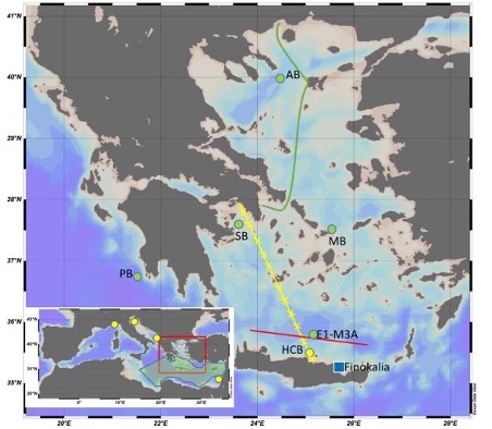
Platforms in Cretan Pilot Supersite
| Operational observation systems & platforms in the region | Parameters |
| Ferrybox PFB |
T, S, Fluo, O2 +CO2 planned +sampler planned |
| Fixed platform HCB, |
Meteo; SSS, SST; pH (sensorlab) air+water CO2 (ProOceanus) |
| Fixed platform E1-M3A |
Meteo; SSS, SST; T, S, Chl-a, O2 at 20, 50, 75, 100 m; T, S at 250, 400, 600, 1000 m |
| Fixed platform SB |
Meteo; SSS, SST; |
| Glider PG |
T, S, O2 every 1m down to 1000m Monthly transects |
| Argo floats | T, S (O2) |
| Calibration Lab | T, S, O2, pH, Fluorescence |
| Monitoring by R/V |
Monthly visits at HCB Biannually visits at E1-M3A (T, S, O2, Fluo, Turbidity, PAR, Phycoerythrin) -Niskin 2,10,20,50,75,100,120m (pH, CT&AT, inorganic nutrients, Chla, bacteria to phytoplankton) -zooplankton net |
Actions
There are 6 actions the Cretan Sea Pilot Supersite.
| Action # | Title | Objective |
| 1 | Solubility and biological pumps | Study air-sea CO2 fluxes and pH using several tools/approaches to understanding their variability and main drivers in an area where there is a sparseness of carbonate system data, pH trends are unknown and the existing AT-S relationships are inadequate. The action targets an optimum strategy in the area to understand its role as source or sink of CO2 as well as the links between carbon, nutrients cycles and primary productivity. |
| 2 | Improved approximations of Primary Production | Improve primary productivity estimates in oligotrophic waters where a large part of primary production is held at most times of the year at depths that are not at satellite reach. Reliable measurements of PP are critical for understanding the carbon cycle and ecosystem function. Estimates will be done by optimising the quality of current datasets feeding model PP predictions and by going through innovative observation systems. |
| 3 | Extreme events affecting phytoplankton – AQUACOSM collaboration III | The Action identifies the extreme events in the CRETAN PSS area. It studies the improved ways to analyse the effects of extreme events on phytoplankton communities with existing systems, via multiple sensors, multiple platforms and mesocosms. In parallel, improved calibration practices for sensors used in oligotrophic conditions are examined. A joint mesocosm experiment is planned with AQUACOSM-plus, aiming to provide support in the continuous monitoring of phytoplankton responses in mesocosms. The Action improves regional synergies between experimental and observational marine communities studying the same ecological questions. |
| 4 | Upscale of Regional Data to a wider area | The action aims to more realistically simulate air-sea CO2 fluxes using a 3D hydrodynamic/BGC/Carbonate ecosystem model (LTL, based on ERSEM). The model will be validated with CRETAN PSS in situ and satellite data via the enhancement of corresponding data acquisition (Action #1) to identify potential biases and necessary modifications (CT/AT initial fields and land-sea inputs, air-sea CO2 flux parameterisation etc). The final 3D model version will be used to evaluate the representativity (“footprint”) of the Cretan Sea solubility pump (air-sea exchanges and carbonate system) in the wider Eastern Mediterranean Sea, to promote the upscaling value of the Regional Data from CRETAN PSS. |
| 5 | New sampling strategies, new technologies, best practices | Design new sampling strategies, evaluate novel technologies, improve estimation algorithms, and revisit best practices to promote the biological measurements in low-biomass areas. Increase links with industry and other technology-related projects. Plan with other RI common benefit sampling strategies. |
| 6 | Partnership building | The Action works at three combined and multiple levels of partnerships: (i) Collaboration schemes between PSSs and IRSs, transfer of knowledge, supply of supporting hardware and human resources, in order to tackle regional and common research questions (feed to WP1, WP3, WP9). (ii) Alliance with other environmental RIs, to enable joint studies and get access/provide supporting data, new technologies. Mapping of environmental RIs in the region (strategy, responsibilities etc) and demonstration of cases of partnership/collaboration (iii) Promote the added value of integrated coastal observations to regional initiatives by providing a demonstration of PSS activities. Added-value of integrated observations and new products resulting from a PSS approach disseminated to regional initiatives, specifying opportunities, challenges and future needs. [combination of original topics vi, vii and viii in DoA] |