Concept Definition
JERICO-CORE is the unified central hub of JERICO-RI to discover, access, manage and interact with JERICO-RI resources including services, datasets, software, best practices, manuals, publications, organisations, projects, observatories, equipment, data servers, e-libraries, support, training and similar assets.
Vision
JERICO-CORE aims to provide a coastal ocean resources environment of the JERICO Research Infrastructure that facilitates both enhanced (virtual) access to all JERICO-RI related resources and the development of coastal focused services.
Mission
The mission of JERICO-CORE is to improve coastal data and information FAIRness by facilitating the development of services to support specialised thematic research activities and building synergies for coastal ocean resources and services between JERICO-RI and other international research data infrastructures.
JERICO-CORE concept explanation
The JERICO-CORE general concept is illustrated by the structure shown in Figure 1 which is a conceptual view of JERICO-CORE. In this, it illustrates the connectivity between functional capabilities and services. Underlying the architecture is flexibility to deal with innovation in science and engineering and meet new demands of users as new capabilities come online. Thus, the system is designed to service current users and support evolution and growth for future needs. In addition to structure, the operating system must have a compelling and intuitive user interface that encourages continuing use. It must also have operational stability and transparency to build and maintain user trust. The architecture and operating environment for JERICO-CORE must deal with the challenge that coastal resources are distributed among JERICO-RI infrastructures using a diversity of standards and implementation methodologies. Resource providers collect these resources following workflows described and accepted in the ocean and coastal domain. However, there is not always a clear connection between resources that are of a different nature. The JERICO-CORE infrastructure collects information about these resources through the existing providers of data, metadata, software services, documents and videos. The information of these assets is interconnected in a knowledge base catalogue that is at the core of the infrastructure and offers a broad view of the data as well as observation and operation processes and capabilities in JERICO-RI. The JERICO-CORE inventory represents the relation between the virtual and physical assets from the JERICO Research Infrastructures distributed worldwide among scattered systems. The cross-related nature of the information in the JERICO-CORE inventory facilitates the way resources are found and then accessed at the original source. Therefore, the knowledge of the relationship between data, information, metadata, documentation, tools and workflows facilitates the traceability of assets and enhances the FAIRness of the data.
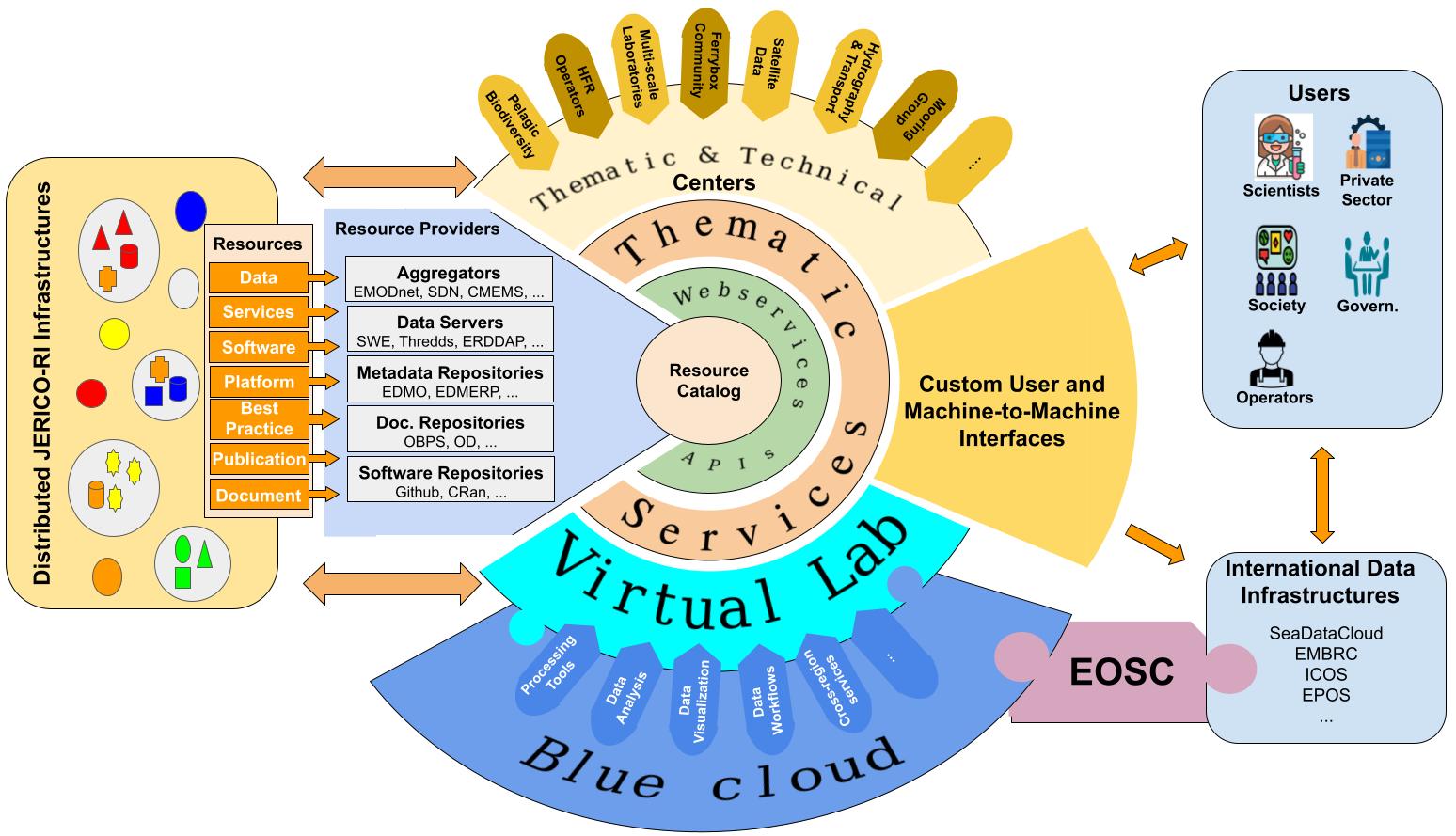
Included in this knowledge-based environment, a layer of thematic services will support JERICO-RI by helping the development of customised tools that use the available information. These tools are made available in a collaborative virtual research infrastructure (VRE) supported by Blue Cloud. Tools are developed in this framework with direct access to the information and the access of JERICO-RI data, products and services. Access to the resources of the catalogue will be provided via an API and web services and support machine-to-machine interoperability. JERICO-CORE will support thematic and technical centres that are defined in the JERICO-RI structure (see Figure 2). In the context of the European Open Science Cloud (EOSC), collaborative developments and improved access to resources, tools and services in a common infrastructure will enhance the collaboration with other research infrastructures. This two-way interoperability will benefit both JERICO-RI and its stakeholders.
These resources and services will be accessible to scientists, the private sector, society, government and technical operators through customised user interfaces to assist their needs. Additionally, external users and international data infrastructures will benefit from machine-to-machine interfaces to automate the access to JERICO-RI assets. Machine-to machine access to services and underlying resources will enhance the interoperability of JERICO-RI to other international infrastructures and allow research across domains and fields.
The motivation for JERICO-CORE is that many coastal ocean problems are complex, requiring experts in different disciplines to co-design and implement solutions. At the simplest scale, observers and data managers will work together to have the data and information in a consistent and easily readable formats. At a higher level, monitoring and understanding of the coastal physical oceanography, where, for example, examining the water mass flows around the Iberian Peninsula, requires multiple sensors, observations and a range of expertise. As we approach the highest level, such as sustainability of marine biodiversity, oceanography expertise and data in physics, biogeochemistry, biology and ecosystems is needed over multiple times and scales. The services described in the next section illustrate a range of capabilities offered by JERICO-CORE
Services
This section contains specific examples of possible services that are explored in the context of JERICO-S3. A complete list of services that interest the community and nations should be gathered in the context of JERICO-DS. There are multiple classes of service available through JERICO-CORE. These involve search services, processing services, tools, common method descriptions and documentation access. Some examples of these are as follows:
- Example of search services: basic search and ontology-based discovery
The resource catalogue contains all the information of the JERICO-CORE assets (documents, data, platforms,…). This information is collected from European providers and linked together to obtain the relations between assets. In addition, a set of taxonomies (e.g. BODC) is used to represent the concepts of the information. Searching capabilities include listing resources of a specific type based on filtering criteria. However, the way the information is stored will allow users to look in a more complete way for information based on their needs, concepts or relation to other assets. For example, a user may be interested in knowing,
- What are the datasets produced by a specific organisation?
- What are the salinity data in a specific region?
- What are the best practices for operating a specific type of platform?
- What are the reports or publications related to a specific mission of a glider?
- What are the documents that are related to the concept of “Mediterranean marine biology”?
The questions that can be answered are endless.
- Examples of basic thematic services: HF Radar (HFR) inventory and European HFR node
With these search capabilities, we can easily imagine a web service that allows us to search for the list of HFR platforms and their location in order to display them on a map using geolocation information. The metadata related to these platforms allows users to click on each platform and be redirected to get the list of datasets that were produced and the documents related to each of the HFR stations.
Moreover, the information of these platforms can be matched to the one collected by the European HFR node in order to visualize the gaps between the two databases (the JERICO-CORE catalogue and the EU HFR database)
- Example of sharing and developing tools: glider and HFR D2PTS
A virtual research environment (VRE) is a collaborative framework that supports the creation of software tools in a shared environment. JERICO-S3 project aims to demonstrate the feasibility of such services by developing four data-to-product thematic services (D2PTS) in the context of Task 7.5.2. An example of a service that can be used in such environments is software that allows the calculation of water mass transport calculations from glider data (see glider D2PTS). This tool has been developed by SOCIB and has been applied in the Western Mediterranean region. The water mass transport software is shared as a service and run in the SOCIB data infrastructure. It is recorded in the resource catalogue as an available service that can be requested by the community. The vision is to deploy the components and libraries in the VRE in order to allow running the service in custom workflows and configurations by different groups. Another example of a service to be deployed in the JERICO-CORE VRE is based on the tool providing gap filled surface data products from HFR data (see HFR D2PTS).
There are some interesting features of running these services in a VRE framework. Libraries and other tools are made available to accelerate development. Moreover, these services will profit from the standard functionality to facilitate transferring data to European aggregators and other common data management operations as defined in the JERICO-RI data management plans.
- Example of advanced services: BGC D2PTS, transboundary and global processes
Advanced services are the ones that take advantage of both the collaborative environment provided by the VRE and the knowledge that is available in the resource catalogue. An example of this service is the D2PTS related to the biogeochemical state of coastal areas. This D2PTS will provide regional, combined multiplatform observations products in the Gulf of Finland. As for the other D2PTS, tools can be developed in the VRE. They can take advantage of the information of the resource catalogue to identify platforms in the area and the biogeochemical datasets that these platforms produce as inputs of the processing workflows.
Another example of advanced services could be related to studying transboundary processes, extreme events in a specific region. These kinds of services would require identifying the datasets that are involved in the processes that involve different regions and various types of platforms. It will require building processing tools that allow extracting the required information from the datasets.
At higher levels of complexity are those issues, such as biodiversity sustainability, which require broad collaboration across scientific disciplines, operations and policymakers. The information will need to accommodate variabilities in spatial and temporal scales. It will need to support cultural differences in information access and expectation as problems vary from local to regional to larger scales. Access to a complete knowledge base catalogue and a collaborative VRE infrastructure is most important in order to provide answers to long term variability and climate change. It will require calculating ocean warming and heatwaves based on data from different sources. Moreover, the data quality must be understood by linking the data to calibration information, best practices, operational procedures and all the information providing a hint of the processes and management leading to the available data.
References
- Kickoff meeting e-JERICO framework diagram
- Kickoff meeting – Initial resource flow diagram
- e-JERICO (JS3) resource flow diagram
- Jerico-S3 WP7 progress meeting
- JERICO-S3 T7.5 JERICO week#2 presentation
- From e-JERICO pilot to a reliable and sustainable e-infrastructure