Contact: Lisa Schneinder
Main characteristics of the English Channel and the North Sea
The ENGLISH CHANNEL is a shallow inter-regional coastal continuum influenced by the Atlantic Ocean and the North Sea. The physical configuration (bathymetry, coastline) gives rise to specific hydrological structures (fronts, gyres) that control advection and dispersion and affect transboundary fluxes of nutrients, pollutants and plankton. In terms of hydrodynamics, the most outstanding feature is the tidal current intensity. The region is also strongly impacted by swells and waves coming from the Atlantic or generated locally by wind events. The system is largely affected by the riverine input of freshwater, nutrients and particulate matter. These hydrological and biogeochemical conditions are favourable for the intense development of seasonal primary production that can be locally associated with eutrophication issues and harmful algal blooms. The region represents a significant economic zone where several human activities take place: tourism and leisure, international ports and freight associated with an intense maritime traffic and the exploitation of living (fisheries, aquaculture) and non-living resources (marine aggregates).
Contact for the English Channel Pilot Supersite: Alain Lefebvre
The NORTH SEA is a shallow shelf sea characterised by complex interdisciplinary processes governing a large range of interconnected length and time scales. It is characterised by diverse ecosystems, strong physical influence on biological and biogeochemical processes, high riverine inputs, and significant connectivity to adjacent sea areas. Coastal areas in the North Sea are characterised by strong tidal influences. It is a highly productive area with recurring phytoplankton blooms. As a whole, the North Sea is regarded to be a sink for carbon dioxide. Since the North Sea is surrounded by densely populated, highly industrialised countries, it is influenced by multiple, often conflicting uses, such as fisheries, waste disposal, oil drilling, transportation, coastal defence, offshore wind farms or recreation. While the North Sea is one of the best investigated shelf sea areas around the globe, the understanding of the interconnected forces that govern energy budget, material fluxes, balances, and the factors directly controlling ecosystem dynamics is still patchy at best.
Contacts for the North Sea Pilot Supersite: Holger Brix, Klas Ove Möller
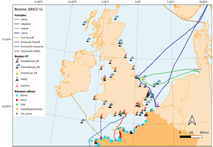
Platforms of the North Sea and English Channel Pilot Supersite
| Operational observation systems & platforms in the region | Parameters |
| MAREL Carnot instrumented station (IFREMER) | Temperature, salinity, turbidity, fluorescence, oxygen conc. + Nutrients, PAR, and meteo to be implemented in 2021. |
| Smile buoy (Ifremer, CNRS) | Temperature, salinity, turbidity, fluorescence, oxygen conc. |
| Scenes buoy (Ifremer) | Temperature, salinity, turbidity, fluorescence + benthic lander: Temperature, salinity, turbidity, waves, currents |
| Astan buoy (CNRS) | Temperature (air/water), wind, atm. pressure, salinity, fluorescence, oxygen, pCO2 |
|
Warp and /WestGabbard (2 x SmartBuoys) |
Temperature (water), salinity, fluorescence, oxygen, turbidity, PAR (0, 1 and 2 meters), phosphate, silicate, ammonia, nitrate, nitrite, phytoplankton (species abundance) |
| Thornton buoy (VLIZ) | Temperature, salinity, conductivity, pH, turbidity, dissolved oxygen, current intensity |
| Benthic Lander MOW1 (RBINS) | Temperature, salinity, acoustic and optic backscatter (turbidity and SPM concentration), turbulence, current velocity, suspended particle size |
| Lysbris FerryBox (Hereon) | Fluorescence, DO, pCO2, pH, salinity, temperature, turbidity, TA |
| Magnolia Seaways FerryBox (Hereon) | CDOM, fluorescence, DO, pCO2, pH, salinity, TA, temperature, turbidity |
| FunnyGirl Ferry Box (Hereon) | CDOM, pH, DO, fluorescence, salinity, temperature, turbidity |
| Cuxhaven (stationary) Ferry Box (Hereon) | DO, salinity, temperature, CDOM, fluorescence, PAR, pH, turbidity, phosphate, silicate, ammonia, nitrate, nitrite |
| Norrona FerryBox (NIVA) | Salinity, temperature, turbidity, chl a and cDOM fluorescence, DOsat, DOconc, pCO2/pH (in 2021) |
|
Connector FerryBox (NIVA / RWS) |
Salinity, temperature, turbidity, chl a and cDOM fluorescence, DOsat, DOconc, pCO2/pH (in 2021) |
|
RV Thalassa FerryBox (IFREMER) |
Temperature, salinity, oxygen conc. and saturation, turbidity, spectral fluorescence. |
|
RV Côtes de la Manche (CNRS) |
Temperature, salinity, the possibility of connecting other sensors |
|
RV Antéa (IRD) |
Temperature, salinity, possibility of connecting other sensors |
| RV Sepia II (CNRS) | Temperature, salinity, possibility of connecting other sensors |
| RV Cefas Endeavour FerryBox (CEFAS) | Temperature, salinity, fluorescence, turbidity, oxygen, spectral fluorescence (possibility connection with flow cytometry) |
| RV Simon Stevin underway system (VLIZ) | Temperature, conductivity, turbidity, oxygen, nutrients (nitrate, phosphate and silicium), surface pCO2, and fluorescence |
| COSYNA Helgoland cable observatory (AWI/Hereon) | Temperature, salinity, turbidity, fluorescence, oxygen, underwater camera system |
| Vertical Profiling Lander Helgoland (AWI/Hereon) | Temperature, Salinity, turbidity, fluorescence, plankton and particle imaging, seafloor properties |
Actions
There are 9 actions for the North Sea and English Channel Pilot Supersite.
| Action # | Title | Objective |
| 1 | Harmonised observations of regional C fluxes | At NSEA-PSS, regional data is augmented with data related to carbon cycling, which will advance the regional carbon budget by improving coherent observations of regional C fluxes (air-sea, land-sea, pelagic-benthic, and microbial processes). The first objective will be to harmonise measurements from available platforms in the NSEA-PSS, including applying respective QA/QC. Whenever possible, data will be harmonized with available measurements from the ICOS ERIC. After this is achieved, another objective will be to combine the quality-controlled data with available models and earth observations. |
| 2 | Riverine input to the North Sea | This task aims to compile data of river water runoff and composition from different ongoing measurements. The purpose of this analysis will be the creation of temporally and spatially explicit information about carbon and nutrient transport from land to the North Sea and the Channel that can be used as input values and/or boundary conditions for carbon and nutrient budgets. Collaboration with other RIs (especially DANUBIUS-RI) is central for this task. |
| 3 | Harmonised observations of plankton biomass, diversity and productivity dynamics | The English Channel and the southern North Sea are characterised by diverse ecosystems of strong hydrodynamical influence on biogeochemical and biological processes (as primary productivity) and plankton accumulation and dispersion, low to high riverine inputs, and significant connectivity to adjacent sea areas. These two marginal seas are considered as areas of medium to high productivity and recurring phytoplankton blooms (some of them being considered as Harmful Algal Blooms-HABs of the potential impact on marine food webs as well as human health and economy). We aim to harmonise our in situ observation, and data processing to better characterise and understand the drivers of phytoplankton outbursts and community occurrence and changes at the different scales and consequently implement the ecosystem approach monitoring. |
| 4 | Products for Eutrophication Status Assessment | High resolution (in time and/or in space) monitoring programmes from the Channel-PSS combines different types of biological observations across the region and will be used for demonstrating new shared products to support/complement eutrophication assessments as defined by EU Directives and Regional Sea Convention. These products should help to provide a final classification when there is some doubt about the pressure/impact relationship for a given assessed eutrophication area. |
| 5 | Intercomparison of phytoplankton distribution using data integration | Create and integrate representation of phytoplankton combining different data sources: in-situ observations from various platforms and sensors, satellite data and model data. This activity involves a range of drivers of phytoplankton dynamics, including hydrodynamic transport, river loads (through models), underwater light climate and associated turbidity, and suspended particulate matter (SPM) dynamics. It aims at quantifying the impacts of phytoplankton dynamics in terms of eutrophication and carbon fluxes. This action will also evaluate the potential of merging multi-source knowledge to estimate the spatial and temporal variability of phytoplankton and SPM concentration in response to intense/extreme events and long-term trends. |
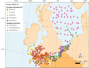
| 6 | Identification of Observational Gaps | Based on a census of existing monitoring programmes (low and high-resolution strategies, incl. ecosystemic/scientific cruises, fixed stations, buoys and FerryBox/SOP, observational gaps will be analysed in both regions, especially related to biological and biogeochemical (including carbon cycle) variables (link to EOV, EBV concept). Analysing needs for institutional interactions will aim to improve regional integration of observations in forthcoming Supersites. |
| 7 | Cross-regional communication between PSSs (the North Sea and Channel) | The aims of a cross-regional communication in the PSS are to highlight in situ technology innovation and implementation, investigate the possibility of transfer to each region of the PSSs (the North Sea and Channel) as well as the platforms, and investigate how to share approach/tools and knowledge from experience between partners to be applied at the regional scales for scientific and societal purposes. |
| 8 | Support to EU directives and ecosystem management | Strongly interface with WP2, task 2.5., this action will contribute to identifying new tools and products developed or optimised within the EC PSS to address WFD/MSFD/OSPAR water quality assessment needs. EC PSS tools and products will be used as proof of concept (from the sensors to the data, from the data to the indicators then, from the indicators to the environmental status assessment). Action #8 results should contribute to EU Directives and Regional Sea Convention monitoring programmes definition and implementation and, to coastal ecosystem assessment and management improvement (IFREMER, Hereon, Deltares, RWS). |
| 9 | Interaction with other RIs on ecosystem studies, eutrophication, coastal management and carbon fluxes | PSSs will interface with other RIs (DANUBIUS-RI, EMBRC-ERIC, ICOS ERIC, LifeWatch-ERIC) by cooperating on key competencies of PSSs and RIs on coastal ecosystem studies and data related to carbon cycling and eutrophication (nutrients particularly) which will advance the interaction with DANUBIUS-RI in resolving land-sea carbon and nutrients fluxes and to facilitate forthcoming collaborations. Particularly, the creation of a network of scientists is sought to be constructed that will allow for better coordination of shared research interests. |