J. Schulz-Stellenfleth (HZG), E. Jansen (CMCC)
The accurate estimation and forecast of biochemical transports in the coastal ocean is a key factor for the understanding of ecological processes and the optimisation of decision processes in coastal management. Due to the spatially heterogeneous structure of most coastal seas, the respective current fields are usually complex and often contain a large variety of small-scale features, which are relevant for many applications. Today’s state of the art numerical models have reached a level, where the most dominant physical processes are taken into account and where the grid resolutions can be chosen small enough to cover a large range of spatial scales. However, there still exists a big number of systematic and stochastic error sources in these models, such as inaccurate bathymetries, insufficient implementation of turbulence dynamics, or errors in the atmospheric and open boundary forcing.
HF radar systems are so far the only instruments suitable for operational use, which provide ocean current information with large coverage and at the same time high spatial and temporal sampling. The use of these observations in combination with numerical model information is therefore of high interest both for model optimisation and forecast improvements. One of the very interesting aspects of the work in JERICO_NEXT is that coastal seas with very different dynamical characteristics are investigated within a common framework. In this particular task CMCC and HZG were concerned with the assimilation of HF radar data in the Adriatic Sea and in the German Bight respectively. The dynamics of the Adriatic Sea is strongly influenced by baroclinic processes and complicated interactions between the ocean and atmosphere. The German Bight on the other hand is extremely shallow and strongly dominated by tides.
Because of the different dynamics it was clear right from the beginning that there is no single data assimilation method that is optimal for all European coastal seas. The key factors to be taken into account in the design of an assimilation scheme are
- The dominant error sources in the numerical models
- The temporal and spatial correlation length of these errors
For the German Bight the bathymetry and bottom roughness parameterisations are of particular concern. Because of the domination by tides, the memory of the German Bight system is very short and the information provided by measurements is usually lost relatively quickly. The processes in the Adriatic Sea on the other hand, take place on a much long time scale and mixing mechanism play a much more important role. The impact time of observations in a data assimilation system is therefore also usually longer in the Adriatic than in the German Bight.
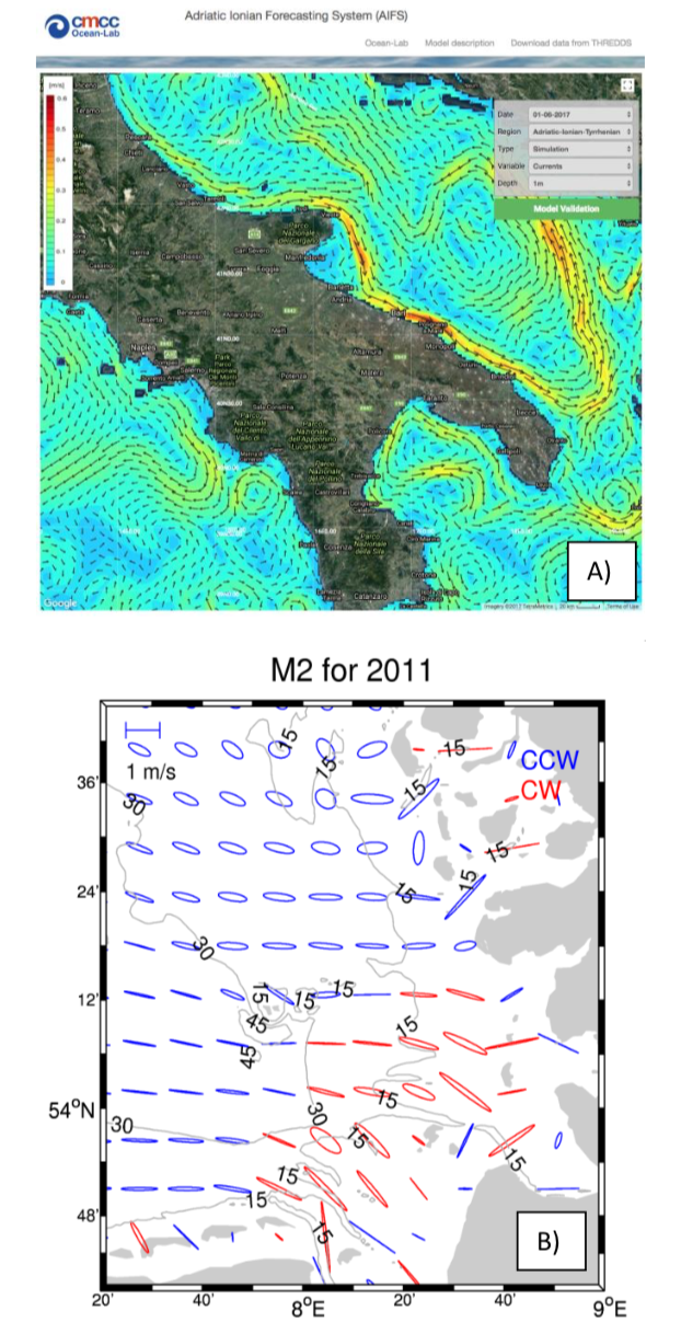
Fig. 1A shows as an example a circulation pattern in the Western Adriatic Sea as predicted by the Adriatic-Ionian Forecasting System (AIFS) for June 1, 2017. One can see a large variety of different boundary currents and ocean eddies. Fig. 1B shows tidal ellipses estimated using model data from the Coastal Observing System for Northern and Arctic Seas (COSYNA) modelling system. The ellipses refer to the 12.4 hourly M2 tide with the colours indicating the sense of rotation of the current vectors. The grey isolines refer to the bathymetry and indicate that the currents in the German Bight are in many places strongly steered by topographic features like tidal inlets.
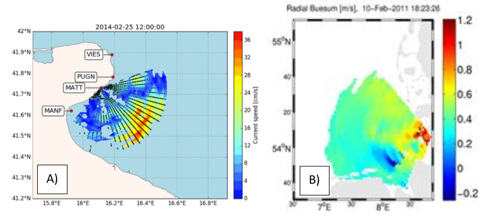
Fig. 2 shows the geometry of HF radar measurements taken in the Adriatic (A) and the German Bight (B). Radar data from four antenna stations in the Adriatic and three antenna stations in the German Bight were used. For illustration, Fig. 2 A and B show radial current measurement obtained from a single station (Mattinata and Büsum).
Two different approaches were used to combine model data and observations to optimise estimates for transports:
- An Ensemble Kalman filter was used for the Adriatic to assimilate HF radar data in combination with complementary salinity and temperature observations.
- A variational 4DVAR approach was used for the German Bight to assimilate HF radar data in combination with tide gauge measurements.
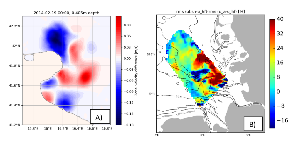
As an illustration Fig. 3a shows the modification of the surface current field in the Adriatic after one assimilation cycle for the zonal component. Fig. 3b shows the relative improvement of the zonal current component in the German Bight achieved by assimilation of current and water level information.
There were two main lessons learned from the work done on HF radar data assimilation in the Adriatic and the German Bight:
- The assimilation schemes have to be adjusted to the specific errors and time scales of the model system.
- It is often beneficial to assimilate measurements in addition to the HF radar surface current observations.
For the Adriatic additional temperature and salinity measurements provided valuable information on important baroclinic processes and for the German Bight the use of tide gauge data further improved the estimation of vertically integrated transports.
As an outlook one can say that the data assimilation schemes, which were optimised for HF radar measurements in two very different coastal ocean systems, are suitable to improve transport estimates. One has to be aware however that these methods have to be adjusted continuously in particular concerning new developments in the model community, e.g., the trend towards higher spatial resolutions, two-way nested models, unstructured grid models, or coupling of various model compartments. This model evolution process is for example very visible in the CMEMS system, which can be a good guideline for future developments in the data assimilation sector. With the increasing spatial resolutions covered by CMEMS, HF radar observation will be of growing relevance for this European infrastructure concerning both validation and data assimilation.