-
CNR- ISMAR is working on the deployment of a new HF radar system in the region of Cinque Terre (NW Mediterranean).
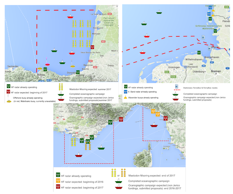
Duration: 2016- 2018.
Objectives: The NW Med area is characterized by the presence of the Liguro-Provenco-Catalan Current also called Northern Current (NC) that flows westward along the coasts of Italy and France and it is characterized by a complex time variability covering a large spectrum of scales. These new deployments will allow to study the variability of this current and associated transport. -
MIO-CNRS has been working on the deployment of a new HF radar system off Nice (NW Mediterranean) and will be analyzing this new data to study the NC current.
Duration: 2016 – 2018.
Objectives: The installation of the second HF radar site off the coast of Nice in the Ligurian Sea area extended the observation zone to the full coastal area, from Italian coast to the Gulf of Lion, allowing a much larger coverage of the Northern Current. - IFREMER will be performing two oceanographic campaigns in summer 2017 to deploy MASTODON MOORINGS and retrieve additional information in the NW Mediterranean and the SE Bay of Biscay.
Duration: 2017, one week for the cruise, one month for the moorings.
Objectives: to better describe the true nature of internal waves over the continental shelf in both study areas.
-
IFREMER and AZTI are working to install in 2017 a new HF radar antenna in the French coast of the SE Bay of Biscay to complete the existing system.
Duration: 2017, for one year.
Objectives: To overcome one of the clearest limitations of the present configuration which is the lack of HFR coverage along the Basque Coast, due to the small angle amongst existing radials generated by two antennas in the Basque Coast. The installation of the third antenna will enable the inter comparisons between a Phased Array (PA) and a Broad-Beam (BB) system in the area, make further analysis on observational errors (in the area covered by the three antennas where there will be redundant data) and on wave data retrieval. -
HZG will be performing numerical experiments in the German bight using data from existing HF radar systems and tide gauges.
Duration: 2016 -2018.
Objectives: the potential of the combined use of HFR data and tide gauge measurements in an assimilation procedure will be analyzed. A pre-operational assimilation system for HFR data is already running at HZG in the framework of the COSYNA system. The added value of water level measurements for this system will be assessed with a particular focus on the estimation of 4D transports. This includes the definition of suitable metrics for both Lagrangian trajectories and volume transports through transects.